Hike: Cool Spring Waterfall

Hike: Cool Spring Waterfall

Distance

3 Miles

Route Type

Out & Back

Difficulty

Easy

Description

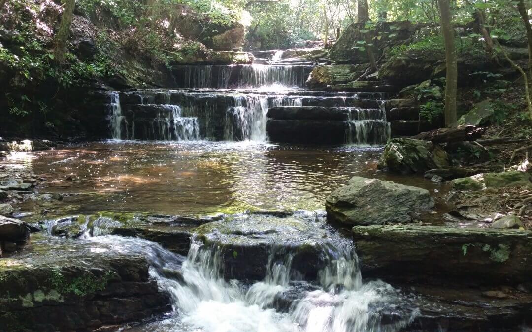
This out-and-back hike takes you on a paved path through the old golf course along the Shenandoah River, then off-road on a flat footpath that winds through a grove of paw-paw trees, across a stream over stepping stones, and then a few more steps until you reach a beautiful waterfall.

The land you’re walking through was the site of the Battle of Cool Spring in 1864, much later became a golf course, and recently Shenandoah University reclaimed the property and maintains it as an outdoor classroom for both its community and the general public.

Beyond the waterfall is the River Ridge Trail, which connects into a network of trails, including the Appalachian Trail (just north of Raven Rocks).

Map

Parking

Coming from Round Hill, head west on Route 7. Right before you reach the Shenandoah River, turn right onto Parker Lane. Warning: This turn comes up fast, so be prepared and mind the cars behind you if you stop suddenly.

Follow Parker Lane until you reach the Cool Spring lodge. In front of the lodge is a big parking lot.

Hike: Raven Rocks Hollow Run

Distance

4 Miles

Route Type

Out & Back

Difficulty

Moderate

Description

This out-and-back hike takes you up and away from Rte 7 for about 1.5 miles before a half-mile steep descent to Raven Rocks Hollow Run, the turnaround spot. You’ll find a nice shady place to hang out and enjoy a snack before returning south to your car. If you’re thirsty, there’s a spring about 100 yards down a blue blaze trail where you can collect water (filtration recommended).

Hiking Upward has more great information. Their hike takes you all the way to the Raven Rocks cliff, which offers a beautiful view for only one more mile (round trip).

Map

Parking

Coming from Round Hill, you have two parking lots to choose from:

  • Raven Rocks: On your right at the intersection of Rte 7 and Pine Grove Rd (SR 679). This lot is closest to the trailhead, but is much smaller and fills up fast. Pay attention to the signs and do not park on the side of Pine Grove Rd unless you want to risk getting towed.
  • Bear’s Den: On your left at the intersection of Rte 7 and Blue Ridge Mountain Road (SR 601). This lot is much bigger, but requires you to cross Rte 7 to reach the trailhead.


Bear's Den Parking Lot

Raven Rocks Parking Lot

Hike: Keyes Gap to David Lesser Shelter

Hike: Keyes Gap to David Lesser Shelter

Distance

6 Miles

Route Type

Out & Back

Difficulty

Moderate

Description

A simple walk in the woods along the Appalachian Trail starting from the Keyes Gap parking lot turning around point at the David Lesser shelter – an excellent example of an Appalachian Trail shelter used by thru-hikers walking from Georgia to Maine. It’s the perfect midway point to relax and eat your lunch, complete with a picnic table and swing. Just downhill from the shelter is a stream where you can collect water (filtration recommended).

A little local history on Keyes Gap from Wikipedia:

Keyes Gap or Keyes’ Gap is a wind gap in the Blue Ridge Mountain on the border of Loudoun County, Virginia and Jefferson County, West Virginia. The gap is traversed by Virginia State Route 9/West Virginia Route 9. The Appalachian Trail also crosses the gap.


Originally known as Vestal’s Gap, the 906 feet (276 m) gap is one of the lowest crossings of the Blue Ridge in Virginia. During the colonial period the main road between Alexandria and Winchester ran through the gap. As such, part of General Edward Braddock’s army under George Washington crossed through the gap on their way to Fort Duquesne during the French and Indian War.


By 1820, the main route west became the newly completed Snickers Gap Turnpike which crossed the Blue Ridge to the south at Snickers Gap, and Keyes Gap lost its prominence. Despite this, Keyes Gap was still of strategic importance during the American Civil War, as it provided an alternate “back route” from Virginia to the key point of Harpers Ferry.

Map

Parking

Coming from Round Hill, on the right side (north) of Route 9 right at the WV / VA border. Parking spaces are limited, so carpool when possible.