by Sean Lloyd | Feb 5, 2019
Want to help make the Round Hill Appalachian Trail Festival happen?
We’d love to have your help. You can post ideas on the festival page (https://www.facebook.com/roundhillat/), send us links, share our posts, chair a committee….
You can also join us in person on Tuesday, February 26, at B Chord Brewing (future site of our fest) to talk about what comes next…please bring all ideas, big and small!

by Sean Lloyd | Dec 15, 2018
Stop By, Say Hi at our Kick-Off & Open House. Learn more about us and our upcoming events
— Appalachian Trail Art Show
— Appalachian Trail Festival
— Community Hikes
— Screen-Free Week
— Croquet Tournament

by Sean Lloyd | Dec 6, 2018
Start the new year on the good foot! Everyone welcome — families, friends, kids. A beautiful hike at Sky Meadows State Park on the Lost Mountain side (30 minutes from Round Hill).
We’re supporting two hikes, you are free to choose the shorter or longer route. Hike B includes Hike A, but adds an extension for a longer walk.
Hike A
Distance = Rolling Meadows trail, approx. 2.5 miles
Difficulty = ( Easy)
Hike B.
Distance = Rolling Meadows (2.5 miles) + Lost Mtn (2.2miles)= 4.7 miles total
Difficulty= some easy and some more difficult, including a climb
You can find a trail guide here –> http://www.dcr.virginia.gov/state-parks/document/data/trail-guide-skymeadows.pdf
Bring whatever you need to stay comfortable: water, snacks, comfortable shoes, warm jacket, hat, gloves, etc…
A few simple notes:
— The hike will happen rain or shine.
— The trailhead parking lot is on the East side of Rte 17, the Lost Mountain side (opposite side from the main park entrance and house).
— Hike begins @ noon (no waiting for latecomers)
— Plan to arrive at least 5 minutes early. Folks will need to sign-in, which includes a simple waiver form.
— There is no waitlist. All comers are welcome.
As always, it’s important to know your own abilities and stay within them.
See you there!
–Carol

by Sean Lloyd | Oct 17, 2018
Everyone welcome — families, friends, kids. A simple walk in the woods along the Appalachian Trail with the David Lesser shelter at the turnaround point – an excellent example of an Appalachian Trail shelter used by thru-hikers walking from Georgia to Maine. It’s the perfect midway point to relax and eat your lunch, complete with a picnic table and swing. The shelter area is also a wide-open space in the woods for kids to play & explore.
Just downhill from the shelter is a stream where you can collect water (filtration recommended). I’ll bring a water filter if you want to try one out.
More info at ——–> https://roundhill.at/hike-keyes-gap-to-david-lesser-shelter/
Distance = 6 miles (3 miles to shelter, 3 miles back)
Difficulty = Moderate
Bring whatever you need to stay comfortable: water, snacks, comfortable shoes, etc…
A few simple notes:
— The hike will happen rain or shine.
— Pack a lunch and water
— See the link to our website for the trailhead parking lot location. It’s a small parking lot, you’ll be able to find us.
— Hike begins @ 10 am (no waiting for latecomers)
— Plan to arrive at least 5 minutes early. Folks will need to sign-in, which includes a simple waiver form.
— There is no waitlist. All comers are welcome.
As always, it’s important to know your own abilities and stay within them.
See you there!
–Carol

by Sean Lloyd | Aug 16, 2018
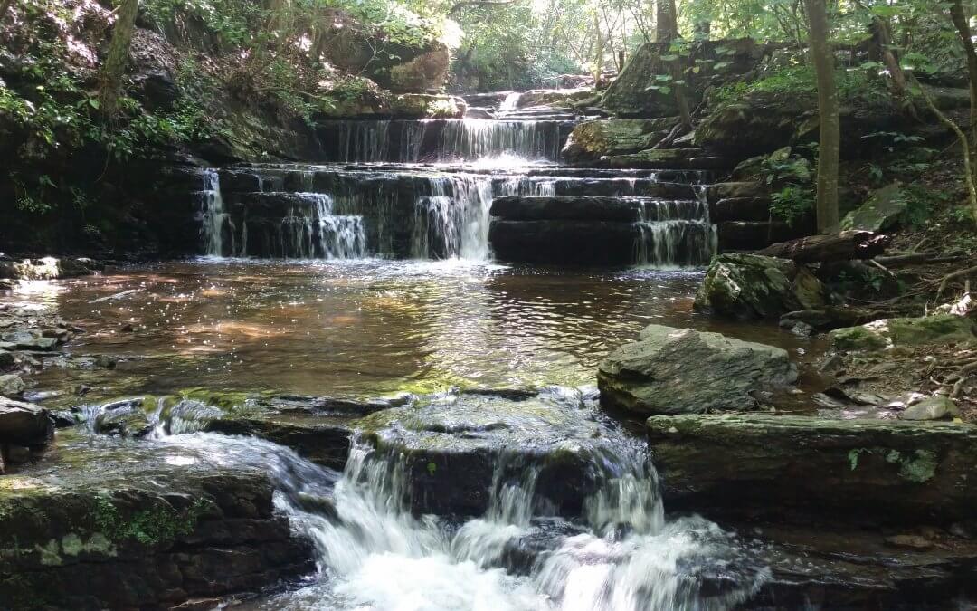
Everyone welcome — families, friends, kids. This walk takes you on a paved path through the old golf course along the Shenandoah River, then off-road on a flat footpath that winds through a grove of paw-paw trees, across a stream over stepping stones, and then a few more steps until we reach a beautiful waterfall. If you feel like exploring more upstream, the reward is a series of cascading waterfalls.
More info at ——–> https://roundhill.at/hike-cool-spring-waterfall/
Distance = 3 miles (1.5 miles to the waterfall, 1.5 miles back)
Difficulty = Easy
A few simple notes:
— Keep an eye out for Sean in the main parking lot (belongs to Shenandoah River Campus at Cool Spring Battlefield)
— Dress kids in clothes they can get wet.
— The hike will happen rain or shine.
— Pack water and snacks (if you want)
— Hike begins @ 10 am (no waiting for latecomers)
— Plan to arrive at least 5 minutes early. Folks will need to sign-in, which includes a simple waiver form.
— There is no waitlist. All comers are welcome. Bring a friend.
by Sean Lloyd | Aug 16, 2018 | hikes
Description
This out-and-back hike takes you on a paved path through the old golf course along the Shenandoah River, then off-road on a flat footpath that winds through a grove of paw-paw trees, across a stream over stepping stones, and then a few more steps until you reach a beautiful waterfall.
The land you’re walking through was the site of the Battle of Cool Spring in 1864, much later became a golf course, and recently Shenandoah University reclaimed the property and maintains it as an outdoor classroom for both its community and the general public.
Beyond the waterfall is the River Ridge Trail, which connects into a network of trails, including the Appalachian Trail (just north of Raven Rocks).
Parking
Coming from Round Hill, head west on Route 7. Right before you reach the Shenandoah River, turn right onto Parker Lane. Warning: This turn comes up fast, so be prepared and mind the cars behind you if you stop suddenly.
Follow Parker Lane until you reach the Cool Spring lodge. In front of the lodge is a big parking lot.
by Sean Lloyd | Aug 8, 2018
Join us in learning best practices to follow when enjoying the outdoors — the 7 Leave No Trace Principles. We’re honored to have guest speaker Rush Williamson from the Potomac Appalachian Trail Club (PATC).
We’ll meet at Round Hill Town Hall (23 Main St).
Leave No Trace Principles
————————————
1. Plan ahead and prepare.
2. Travel and camp on durable surfaces.
3. Dispose of waste properly.
4. Leave what you find.
5. Minimize campfire impacts (be careful with fire).
6. Respect wildlife.
7. Be considerate of other visitors.
For more on Leave No Trace —> https://lnt.org/learn/7-principles

by Sean Lloyd | Aug 8, 2018
The Park entrance fee is $25 per vehicle, and the tent camping fee at Big Meadows Campground is $20 if you plan to stay over. First come – first served sites may go quickly, so arrival early Sunday afternoon may be a good idea!
The park is sponsoring many activities this weekend! See https://www.nps.gov/shen/planyourvisit/night-sky-festival.htm
for details.
Tips for watching the Perseids: http://earthsky.org/?p=2087
At 9:00 pm, we will gather at the flagpole in front of the Byrd Visitor Center, and at 9:30 we will walk over to and hike up the Rapidan Fire Road for about a mile in the dark. After three or four hours of watching our planet defend itself from cosmic invaders, we will hike back (but the best showers happen after midnight!)
BRING RED FILTER FLASHLIGHTS and extra batteries! White lights ruin everyone’s night vision. Optional — bring blankets or beach chairs for sitting back and counting meteors.

by Sean Lloyd | Jun 25, 2018
Distance = 4 miles
Difficulty = Moderate
Everyone welcome — families, friends, kids. We’ll meet at the Bear’s Den parking lot (lower) and head north across Rte 7 to Raven Rocks Hollow, hang out, and enjoy the shade and stream!
If you’re thirsty, at the turnaround spot there’s a spring about 100 yards down a blue blaze trail where you can collect water (filtration recommended).
More info at —–> https://roundhill.at/hike-raven-rocks-hollow-run/
Bring whatever you need to stay comfortable: water, snacks, comfortable shoes, etc… Please note that parts of this trail are rocky.
All levels of ability are able to finish this hike. That said, it is a walk on uneven ground. So it’s important to know your own abilities and stay within them.
A few simple notes:
— Keep an eye out for Carol & Sean in the parking lot near the Bear’s Den trailhead.
— The hike will happen rain or shine.
— Pack water and snacks (if you want)
— If you want to meet us at the trailhead, see the link to our website for the trailhead parking lot location.
— Hike begins @ 10 am (no waiting for latecomers)
— Plan to arrive at least 5 minutes early. Folks will need to sign-in, which includes a simple waiver form.
— There is no waitlist. All comers are welcome.
See you there!
by Sean Lloyd | Jun 25, 2018 | hikes
Description
This out-and-back hike takes you up and away from Rte 7 for about 1.5 miles before a half-mile steep descent to Raven Rocks Hollow Run, the turnaround spot. You’ll find a nice shady place to hang out and enjoy a snack before returning south to your car. If you’re thirsty, there’s a spring about 100 yards down a blue blaze trail where you can collect water (filtration recommended).
Hiking Upward has more great information. Their hike takes you all the way to the Raven Rocks cliff, which offers a beautiful view for only one more mile (round trip).
Parking
Coming from Round Hill, you have two parking lots to choose from:
- Raven Rocks: On your right at the intersection of Rte 7 and Pine Grove Rd (SR 679). This lot is closest to the trailhead, but is much smaller and fills up fast. Pay attention to the signs and do not park on the side of Pine Grove Rd unless you want to risk getting towed.
- Bear’s Den: On your left at the intersection of Rte 7 and Blue Ridge Mountain Road (SR 601). This lot is much bigger, but requires you to cross Rte 7 to reach the trailhead.




Recent Comments